
Location : old cottage [6], Tay Street
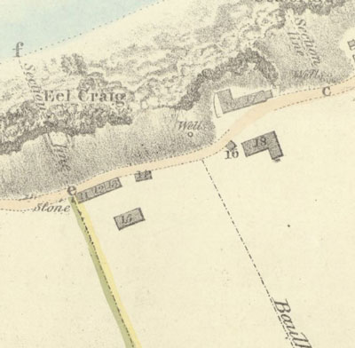
Photo / old map: Map, Steedman 1825, ref. 17 Reproduced with the permission of the National Library of Scotland.
 = Property demolished or site redeveloped
Notes: demolished
Location and Old Maps
Latitude, longitude: 56.441746,-2.940840
View location on the 1855 6-inch map, the 1895 25-inch map, the 1914 25-inch map, the 1966-73 25-inch map, or a 1944-50 aerial photograph at the National Library of Scotland website.
Nearby properties (demolished in red): 1 Robert Street (formerly 2, Robert Street) 3 Robert Street 5 Robert Street 7 Robert Street 18 Tay Street 20 Tay Street 22 Tay Street 24 Tay Street 26 Tay Street 28 Tay Street 30 Tay Street (formerly 32, Tay Street) (formerly 34, Tay Street) (formerly 36, Tay Street) (formerly 38, Tay Street) (formerly 40, Tay Street) (formerly 42, Tay Street) (formerly 44, Tay Street) (formerly 46, Tay Street) (formerly 48, Tay Street) (formerly Royal Bar, 50, Tay Street) 52 Tay Street 54 Tay Street (house on site of 26, Tay Street) drinking fountain, Tay Street (house on site of Royal Hotel, Tay Street) (Royal Hotel, Tay Street) (Royal Hotel, part [2], Tay Street) (Royal Hotel, part [3], Tay Street) (Royal Hotel, part [4], Tay Street) (Royal Hotel, part [5], Tay Street) (Royal Hotel, part [6], Tay Street) (Royal Hotel, part [7], Tay Street) (Royal Hotel, part [8], Tay Street) (Royal Hotel, part [9], Tay Street) (Royal Hotel, part [10], Tay Street) (Royal Hotel, part [11], Tay Street) (Royal Hotel, part [12], Tay Street) (Royal Hotel, part [13], Tay Street) (Royal Hotel, part [14], Tay Street) (Bathing Shelter, Tay Street) (Boat House, Tay Street) (old cottage [5], Tay Street) (old byre [5a], Tay Street) (old cottage [7], Tay Street)
Old Addresses (any dates are approximate and are usually the latest occurence of the address)
| - |
House Names (any dates are approximate and are usually the latest occurence of the name)
| old cottage [6] |
Directory entries (before 1975)
| - |
Census records
| - |
Valuation Roll entries
| Year | No. | Property | Proprietor | Tenant | Occupier | Value | ||
|---|---|---|---|---|---|---|---|---|
| - |
Other Sightings:
| Year | Detail | Source |
|---|---|---|
| 1828 | Buildings shown on map: 'Houses etc' | No image available. National Records of Scotland, RHP30450, Plan of the Braes |
| 1825 | Building shown on map: Ref. 17, Old House & Byre possessed by James Black | National Library of Scotland, Plan of the coast from Newport to Craighead, 1824-25, John Steedman |
| 1822 | Buildings shown on map: Ref. O, Houses possessed by George Wilson & James Black | No image available. National Records of Scotland, RHP30440, Plan of Newport. |
| 1817 | Building shown on map | National Library of Scotland, Survey of the Harbour of Newport, Stevenson, 1817 |
Early Sasines:
| - |
Return to: Home Page Present-day Addresses Properties Map Old House Names Directories Valuation Rolls Sasines Census