East is East, and West is West

and the wrong one I have chose …

[name that tune *]

Certainly in Victorian Newport you may well have chosen the wrong direction – particularly if you were looking for a property in East Newport. Take, for example, Messrs Hutton and Boase (who owned houses within 50 yards of each other in Marytown, albeit 20 years apart).

The legal descriptions of their properties have Tay Street to the north and Union Street to the south, Hutton has Robert Street to the west and Boase has other Marytown properties east and west.

In fact, ALL the Marytown properties refer to Tay Street on the north with Union Street, King Street and Queen Street to the south.

The field behind or above Marytown (Backfield Park – where Woodbine Terrace and Maryfield were built) was referred to as ‘the land south of Marytown’. There are also references to houses and shops on the north side of the High Street.

But look at the map.

Tay Street, Union Street, King Street, Queen Street and the High Street run almost north to south. In other words, Tay Street is WEST of Marytown, and the ‘north’ side of the High Street is actually the west side.

Confused?

Well, the extreme case is given by the plots of land on the corner of Queen Street, James Street and King Street. The field was divided into four plots, described as the NE, SE, SW and NW lots. But on the ground, the NE plot is actually the NW one, the SE is in fact the NE one, the SW one is really the SE one and the NW plot is the SW one. (I wonder if people bought the one they were expecting to buy?)

The reason for all this geographic muddle appears to be – nobody used a compass but assumed that the river was to the north of Newport. Which is true for most of Newport, but not for the part from the foot of the High Street to the foot of James Street – where the coast turns from running west to east, to running south to north, before turning again back to running west to east. As anyone who lives here will tell you, the magnificent sunsets show that these houses look west.

So when you are stuck with directions which don’t appear to be quite right, use the rule ‘if you face the shoreline you are looking north’.

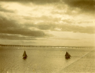
Looking north into the sunset.

(photo by Alexander Robertson c.1896)

Sources:
Sasine Abridgements – 1826.03119, 1866.00933 (for Marytown lot 6, Hutton)
Sasine Abridgements – 1826.03335, 1840.04731 (for Marytown lot 7, Boase)
Town Council Minutes 1906-07 – plans for David Young to build shops on north side of the High Street

* Buttons and Bows, 1947, lyrics – Ray Evans, music – Jay Livingston, Academy Award winner for Best Original Song in ‘The Paleface’ starring Bob Hope & Jane Russell.

How the Property Information is Collated

Over thirty years ago, I drew up a grid which listed in a column all the properties on the south side of Prospect Terrace and, for each property, laid out in a row the owners / occupiers working back in time as far as I could go. I used Dundee directories and old valuation rolls as the sources of the information. This was relatively easy – these properties had changed hands only a few times in over 100 years. There were, naturally, discrepencies with the dates when comparing the data from the two sources but, overall, a fairly comprehensive picture of this one side of one street could be built up.

Over the years, this turned into a Newport- & Wormit-wide project. It was much easier to follow the properties through the valuation rolls than by using the directories, so I gathered together copies of valuation rolls at approximately 5-year intervals back to their start in 1855. This was augmented with the information from the censuses. I gathered large sheets of squared paper and put the information for each street or side of a street on one sheet. Some properties were easy to research, others remained stubbornly difficult and a few were impossible. Most entries could eventually be filled in with ink, but there were many pencil entries and not a few question marks.

Roll on to the present day when computer-searching makes things much easier. The data, of course, has to be entered before it can be searched since none of it was online. Other sources have been gathered – voters’ rolls, sasine abridgements, valuation office records, maps, etc., etc. Each source had obviously gathered information for its own specific purpose and the details of names, addresses and dates were not easily linked together. And, needless to say, the complexity, ambiguity and incomplete nature of the information can create its own problems. It helps to have local knowledge – I was a message boy for Beatt & Tait, the grocers, in the 1960s; worked on the Christmas post in the early 70s; and worked in the summer as a student labourer for Newport Town Council until it was abolished and ‘regionalisation’ took over. The background this gave me – particularly with addresses and house-names – was invaluable. To do this exercise elsewhere would be extremely difficult, but not impossible.

I am currently trying to put all this information out in the public arena, checking it all over as I go. It is a time-consuming and complex job, but the satisfaction is immense. However, there will always be areas of doubt – so I can only give a ‘best guess’ as to who lived where and when – but I am fairly confident that the vast majority are accurate.

Anyway, as an indication of the thought processes involved I can give the problem of two semi-detached properties in King Street: present-day numbers 7 and 9.

I had tracked each property through the valuation rolls back from 1967 at 5-yearly intervals to 1855. Consistently this told me that, back to 1876, no. 7 was the bigger property (it had the higher rateable value and paid the higher feu duty). It was owned and inhabited by a succession of James Murrays. Indeed I remember Peem Murray when I delivered his mail and I knew that he lived in what is now no. 7 and is the south-western part of the property, and Miss Marshall lived in the other part no. 9 (her door had ‘Marshall’ on the brass letterbox). The present-day street numbering is correct: there are some addresses which are out of numerical sequence but this is not one of them. The two properties were parts of a single property which was split and sold (albeit within the family) in 1876, the southern part going to James Murray, the northern part being retained by the rest of the family of the property’s first owner George Murray. Looking at the 1894 map, James Murray’s house is the larger. So far, so good. I started to tie in the directory entries to the relevant properties. Then came the census. Ah. Recorded in sequence, from south-west to north-east in 1911, 1901, 1891 and 1881, they all showed the smaller property first (in terms of rooms – 3 in the southern property, 4 in the northern one). Something wrong here, surely. Often the census returns aren’t listed in the exact order. But the other houses round about are correctly ordered, and they wouldn’t be wrong for every year.

The only other source that could help is the 1910 Valuation Act Field Books. I have a few transcriptions of these entries which give details of the houses around 1912. Remarkably, I had the entries for these 2 houses. Entry 142 – Miss M Murray, but shown on the map as Mrs Marshall, – same rental and value as in the valuation roll, but it is described as having ‘kitchen, upstairs room with one small room off, attic – 1 room, washhouse common’. Entry 143 – James Murray, the southern property, correct rental and value, ‘containing kitchen, scullery, room with small room off, dry WC, washhouse common’. So there we are – the larger property, with the higher value, actually has a smaller number of rooms than the other one. So all the sources were correct even if it seemed that they weren’t. I just had to tidy up all the directory entries as best I could and declare it ‘completed’.

But I still have a niggling doubt about the census room numbers.