
Location : Kempstane [2], Tay Street
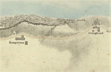
Photo / old map: Map, Steedman 1825. Reproduced with the permission of the National Library of Scotland.
 = Property demolished or site redeveloped
Notes: demolished
Part of a divided property. Other parts: Kempstane
Location and Old Maps
Latitude, longitude: 56.444698,-2.938173
View location on the 1855 6-inch map, the 1895 25-inch map, the 1914 25-inch map, the 1966-73 25-inch map, or a 1944-50 aerial photograph at the National Library of Scotland website.
Nearby properties (demolished in red): 79 Tay Street 80 Tay Street 82 Tay Street 83 Tay Street 84 Tay Street 86 Tay Street 89 Tay Street (Kempstane, Tay Street) 81 Tay Street
Later use of the site : 81 Tay Street
1909-10 Finance Act - Valuation Office: Field Surveys
Reference no. 5
Old Addresses (any dates are approximate and are usually the latest occurence of the address)
| - |
House Names (any dates are approximate and are usually the latest occurence of the name)
| Kempstane [2] |
Directory entries (before 1975) There are 2 entries
| Source | Entry | ||
|---|---|---|---|
| 1925-26 dir | Latto, A., Kempstone cottages - Newport Congl. Union Church : Church-Officers. | location 2 | |
| 1925-26 dir | Latto, A., church officer, Newport Congregational Union Church ; h. Kempstone cottages | location 2 |
Census records
| Year | Address | Head | Notes | Rooms | ||||
|---|---|---|---|---|---|---|---|---|
| 1891 | Kempstane | Swinton | Camilla | 2 | View household | |||
| 1881 | Kempstane | Swinton | Jemima | 2 | View household | |||
| 1871 | Tay Street | Ferrie | William | 2 | View household | [?] |
Valuation Roll entries There are 2 entries
| Year | No. | Property | Proprietor | Tenant | Occupier | Value | |||
|---|---|---|---|---|---|---|---|---|---|
| 1897-98 | 378 | House | William Berry Esq. per Haggart & Burn Murdoch, WS, 140 Princes St, Edinburgh | Mrs Isabella Smith | James Caldwell, stone cutter | 6 | View details | ||
| 1896-97 | 356 | House | William Berry Esq. per Haggart & Burn Murdoch, WS, 140 Princes St, Edinburgh | Mrs Isabella Smith | James Caldwell, stone cutter | 6 | View details |
Railway Map References:
| Plan | Year | Ref | Description | Owner or reputed owner | Occupier | [Comments] |
|---|---|---|---|---|---|---|
| RHP85261 (E & N) | 1845 | 46 | Dwelling houses, outhouses, garden ground, pasture ground, sea braes & private road | William Berry | James Wilson (lessee & occupier), John Harris (occupier) | [not shown. Kempstane] |
| RHP85254 (G & D J) | 1845 | 21 | Dwelling house, barn, byre, stable, sheds and outbuildings | William Berry | James Wilson (lessee); John Harris (occupier) | [Kempstane] |
Other Sightings:
| Year | Detail | Source |
|---|---|---|
| 1825 | Building shown on map: Kempstone | National Library of Scotland, Plan of the coast from Newport to Craighead, 1824-25, John Steedman |
Early Sasines:
| - |
Return to: Home Page Present-day Addresses Properties Map Old House Names Directories Valuation Rolls Sasines Census