
Location : Wormit Farm Cottages at Steading, Naughton Road
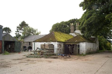
Photo / old map: Historic photo 2004 taken by Harry Prosser
 = Property demolished or site redeveloped
Notes: Some properties demolished. Specific locations are uncertain and could be anywhere on the farm or estate.
Other references can be found at : Wormit Farm Cottages
Introduction
Original locations of Wormit Farm Cottages. Some still used post-1860. Apart from the 1911 census, it is not possible to say who lived in which cottage. All references pre-1860 are here; post-1860 are at Wormit Farm Cottages.
Location and Old Maps
Latitude, longitude: 56.420100,-2.981707
View location on the 1855 6-inch map, the 1895 25-inch map, the 1914 25-inch map, the 1966-73 25-inch map, or a 1944-50 aerial photograph at the National Library of Scotland website.
Nearby properties (demolished in red): Wormit Farm House, Naughton Road
Old Addresses (any dates are approximate and are usually the latest occurence of the address)
| - |
House Names (any dates are approximate and are usually the latest occurence of the name)
| Wormit Farm Cottages at Steading |
Directory entries (before 1975)
| - |
Census records
| Year | Address | Head | Notes | Rooms | ||||
|---|---|---|---|---|---|---|---|---|
| 1911 | Wormit, Cottar House | Brunton | James | B | 2 | |||
| 1851 | Wormit Bothy | Wood | David | View household | ||||
| 1851 | Wormit Cotton | Walker | William | View household | ||||
| 1841 | Wormit Farm | Harris | Alexander | View household | ||||
| 1841 | Wormit Farm | Walker | William | View household | ||||
| 1841 | Wormit Farm | Angus | David | View household |
Valuation Roll entries
| Year | No. | Property | Proprietor | Tenant | Occupier | Value | |||
|---|---|---|---|---|---|---|---|---|---|
| - |
Early Sasines:
| - |
Return to: Home Page Present-day Addresses Properties Map Old House Names Directories Valuation Rolls Sasines Census