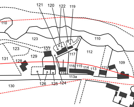
Location : Barn etc, Riverside Road

Photo / old map: Map: RHP85254, Glasgow & Dundee Junction Railway, 1845
 = Property demolished or site redeveloped
Notes: Demolished; ref. 128
Location and Old Maps
Latitude, longitude: 56.430347,-2.967119
View location on the 1855 6-inch map, the 1895 25-inch map, the 1914 25-inch map, the 1966-73 25-inch map, or a 1944-50 aerial photograph at the National Library of Scotland website.
Nearby properties (demolished in red): 1 Beach Road 3 Beach Road (Cottage [1], Beach Road) (Cottage [2], Beach Road) (Cottage [3], Beach Road) Bridge View, Beach Road 22 Riverside Gardens 23 Riverside Gardens 24 Riverside Gardens 79 Riverside Road (Dairy, formerly 81, Riverside Road) (Wormit School, Riverside Road) (Woodhaven Farm Cottage [2], Riverside Road) (Woodhaven Farm Cottage [3], Riverside Road) 81 Riverside Road
Old Addresses (any dates are approximate and are usually the latest occurence of the address)
| - |
House Names (any dates are approximate and are usually the latest occurence of the name)
| Barn, kiln & granary |
Directory entries (before 1975)
| - |
Census records
| - |
Valuation Roll entries
| Year | No. | Property | Proprietor | Tenant | Occupier | Value | |||
|---|---|---|---|---|---|---|---|---|---|
| - |
Railway Map References:
| Plan | Year | Ref | Description | Owner or reputed owner | Occupier | [Comments] |
|---|---|---|---|---|---|---|
| RHP85254 (G & D J) | 1845 | 128 | Malt-barn, kiln & granary | Henry Stewart | Alexander Rhind (lessee & occupier) | [site of 79 Riverside Road] |
Other Sightings:
| Year | Detail | Source |
|---|---|---|
| 1855 | Building NOT shown on Ordnance Survey map. | Ordnance Survey, Six-inch, first edition, Fife sheet 2, 1854-55. |
Early Sasines:
| - |
Return to: Home Page Present-day Addresses Properties Map Old House Names Directories Valuation Rolls Sasines Census
