
Location : old tollhouse, Cupar Road
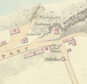
Photo / old map: Map, Steedman 1825. Reproduced with the permission of the National Library of Scotland.
 = Property demolished or site redeveloped
Notes: demolished
Commentary
Replaced by a later toll house on the other side of the road.
Location and Old Maps
Latitude, longitude: 56.440088,-2.940968
View location on the 1855 6-inch map, the 1895 25-inch map, the 1914 25-inch map, the 1966-73 25-inch map, or a 1944-50 aerial photograph at the National Library of Scotland website.
Nearby properties (demolished in red): St Thomas's Church, 1, Blyth Street 3 Blyth Street 2 Blyth Street 4 Blyth Street Blyth Hall, Blyth Street shop, 1, Cupar Road shop, 3, Cupar Road shop, formerly 5, Cupar Road shop, 7, Cupar Road shop, 9, Cupar Road shop, 11, Cupar Road shop, 13, Cupar Road 15 Cupar Road shop, 17, Cupar Road shop, 19, Cupar Road 6 Cupar Road 4 Cupar Road shop, formerly 2, Cupar Road (Newport Toll, Cupar Road) formerly part of 15, Cupar Road (Farm steading, Cupar Road) 28a, High Street shop, 30, High Street shop, 32, High Street 34 High Street 36 High Street shop, 38, High Street shop, 40, High Street shop, 46, High Street shop, 48, High Street shop, 52, High Street shop, 54, High Street shop, 50, High Street (Newport House, High Street) (old house [north 1], High Street) (old house [north 2], High Street) (old house [north 3], High Street) (old house [south 1], High Street) (old house [south 2], High Street) 1 St Marys Lane 3 St Marys Lane 2 Tay Street 4 Tay Street 6 Tay Street
Old Addresses (any dates are approximate and are usually the latest occurence of the address)
| - |
House Names (any dates are approximate and are usually the latest occurence of the name)
| old tollhouse |
Directory entries (before 1975)
| - |
Census records
| - |
Valuation Roll entries
| Year | No. | Property | Proprietor | Tenant | Occupier | Value | |||
|---|---|---|---|---|---|---|---|---|---|
| - |
Other Sightings:
| Year | Detail | Source |
|---|---|---|
| 1825 | Building shown on map: Toll Bar | National Library of Scotland, Plan of the coast from Newport to Craighead, 1824-25, John Steedman |
| 1817 | Building shown on map: 'Toll bar' | National Library of Scotland, Survey of the Harbour of Newport, Stevenson, 1817 |
Early Sasines:
| - |
Return to: Home Page Present-day Addresses Properties Map Old House Names Directories Valuation Rolls Sasines Census