
Location : old cottage [2], Tay Street
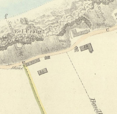
Photo / old map: Map, Steedman 1825, ref. 13 Reproduced with the permission of the National Library of Scotland.
 = Property demolished or site redeveloped
Notes: demolished
Location and Old Maps
Latitude, longitude: 56.440910,-2.940968
View location on the 1855 6-inch map, the 1895 25-inch map, the 1914 25-inch map, the 1966-73 25-inch map, or a 1944-50 aerial photograph at the National Library of Scotland website.
Nearby properties (demolished in red): 2 Tay Street 4 Tay Street 6 Tay Street 8 Tay Street 10 Tay Street 12 Tay Street 14 Tay Street 18 Tay Street 20 Tay Street 22 Tay Street (Bathing Shelter, Tay Street) (old cottage [1], Tay Street) (old cottage [3], Tay Street) (old byre [4], Tay Street)
Old Addresses (any dates are approximate and are usually the latest occurence of the address)
| - |
House Names (any dates are approximate and are usually the latest occurence of the name)
| old cottage [2] |
Directory entries (before 1975)
| - |
Census records
| - |
Valuation Roll entries
| Year | No. | Property | Proprietor | Tenant | Occupier | Value | |||
|---|---|---|---|---|---|---|---|---|---|
| - |
Other Sightings:
| Year | Detail | Source |
|---|---|---|
| 1825 | Building shown on map: Ref. 12, Old Boatman's house lately possessed by George Johnstone | National Library of Scotland, Plan of the coast from Newport to Craighead, 1824-25, John Steedman |
| 1822 | Buildings shown on map: Ref. K, Houses possessed by George Greig, George Johnstone & William Gilchrist | No image available. National Records of Scotland, RHP30440, Plan of Newport. |
| 1817 | Building shown on map | National Library of Scotland, Survey of the Harbour of Newport, Stevenson, 1817 |
Early Sasines:
| - |
Return to: Home Page Present-day Addresses Properties Map Old House Names Directories Valuation Rolls Sasines Census