
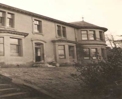
Location : 117 Tay Street
 = Property still standing
Notes: main (west) part; lower floor only from 1974
Part of a divided property. Other parts: 113 Tay Street 115 Tay Street
Location and Old Maps
Latitude, longitude: 56.446727,-2.934639
View location on the 1855 6-inch map, the 1895 25-inch map, the 1914 25-inch map, the 1966-73 25-inch map, or a 1944-50 aerial photograph at the National Library of Scotland website.
Nearby properties (demolished in red): 108 Tay Street 111 Tay Street 113 Tay Street 115 Tay Street
Old Addresses (any dates are approximate and are usually the latest occurence of the address)
| - |
House Names (any dates are approximate and are usually the latest occurence of the name)
| Taygrove |
Directory entries (before 1975)
| - |
Census records
| - |
Valuation Roll entries
| Year | No. | Property | Proprietor | Tenant | Occupier | Value | |||
|---|---|---|---|---|---|---|---|---|---|
| 1974-75 | 161910 | Premises (under reconstruction) | Mrs Ann Campbell | empty | 80 | View details |
Early Sasines:
| - |
Return to: Home Page Present-day Addresses Properties Map Old House Names Directories Valuation Rolls Sasines Census