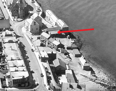
Location : Smithy, formerly 9, Granary Lane

 = Property demolished or site redeveloped
Notes: Demolished
Location and Old Maps
Latitude, longitude: 56.439325,-2.942309
View location on the 1855 6-inch map, the 1895 25-inch map, the 1914 25-inch map, the 1966-73 25-inch map, or a 1944-50 aerial photograph at the National Library of Scotland website.
Nearby properties (demolished in red): (formerly stores, 7, Boat Road) (formerly garages & workshop, 9, Boat Road) (old St David's Inn, Boat Road) (part of old St David's Inn, Boat Road) (Tayside Cottages [NE], Boat Road) (Tayside Cottages [mid], Boat Road) (former house [1], Granary Lane) (former house [2], Granary Lane) (formerly 5, Granary Lane) (Burgh Yard, formerly 11, Granary Lane) (Slaughter House, Granary Lane) (part of Gas Works Lane Granary [1], Granary Lane) (part of Gas Works Lane Granary [2], Granary Lane) (part of Gas Works Lane Granary [3], Granary Lane) (part of Gas Works Lane Granary [4], Granary Lane) (part of Gas Works Lane Granary [5], Granary Lane) (part of Gas Works Lane Granary [6], Granary Lane) (former house [3], Granary Lane) (former house [4], Granary Lane) (former house [5], Granary Lane) (former house [6], Granary Lane) (Newport harbour pack house, Granary Lane) Newport Hotel, 1, High Street Trinity UF Church, 2, High Street 3 High Street 4 High Street 5 High Street office at front, 6, High Street 7 High Street 8 High Street shop, 9, High Street 10 High Street St Mary's Church, High Street shop, 11, High Street 12 High Street shop, 13, High Street 14 High Street shop, 15, High Street shop, 16, High Street (house at gasworks, High Street) (Gas Office, High Street) downstairs property, 9, High Street (cottage south of 4, High Street) (the Waterside (East Water), Old Places)
Old Addresses (any dates are approximate and are usually the latest occurence of the address)
| Gas Lane | ||
| Gas Works Lane | ||
| Old Pier Road | 1961 |
House Names (any dates are approximate and are usually the latest occurence of the name)
| Newport Smithy | from early 1940s |
Directory entries (before 1975) There are 3 entries
| Source | Entry | ||
|---|---|---|---|
| 1961 dir | Don, Old Pier road : Blacksmiths. | ||
| 1960 dir | Don, John J., blacksmith, Old Pier road; h. Seamills, High road | location 2 | |
| 1960 dir | Don, John J., Old Pier road : Blacksmiths. |
Census records
| - |
Valuation Roll entries There are 9 entries
| Year | No. | Property | Proprietor | Tenant | Occupier | Value | |||
|---|---|---|---|---|---|---|---|---|---|
| 1973-74 | 213000 | Smithy | Scottish & Newcastle Breweries Ltd, Abbey Brewery, Holyrood Rd, Edinburgh 8 | John J Don | 32 | View details | |||
| 1972-73 | 213000 | Smithy | Scottish & Newcastle Breweries Ltd, Abbey Brewery, Holyrood Rd, Edinburgh 8 | John J Don | 32 | View details | |||
| 1971-72 | 213000 | Smithy | Scottish & Newcastle Breweries Ltd, Abbey Brewery, Holyrood Rd, Edinburgh 8 | John J Don | 32 | View details | |||
| 1969-70 | 2130 | Smithy | William Berry per Murray Beith & Murray WS, 39 & 43 Castle St, Edinburgh 2 | John J Don | 14 | View details | |||
| 1968-69 | 2130 | Smithy | William Berry per Murray Beith & Murray WS, 39 & 43 Castle St, Edinburgh 2 | John J Don | 14 | View details | |||
| 1967-68 | 787 | Smithy | William Berry per Murray Beith & Murray WS, 39 & 43 Castle St, Edinburgh 2 | John J Don | 14 | View details | |||
| 1966-67 | 787 | Smithy | John Berry PhD per Hagart & Burn Murdoch WS, 10 Atholl Cresc., Edinburgh | John J Don | 14 | View details | |||
| 1964-65 | 787 | Smithy | John Berry PhD per Hagart & Burn Murdoch WS, 10 Atholl Cres, Edinburgh | John J Don | 14 | View details | |||
| 1961-62 | 2324 | Smithy | John Berry PhD per Hagart & Burn Murdoch WS, 10 Atholl Cres, Edinburgh | John J Don | 14 | View details |
Early Sasines:
| - |
Return to: Home Page Present-day Addresses Properties Map Old House Names Directories Valuation Rolls Sasines Census
