
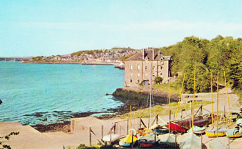
Location : Dinghy park, Woodhaven Pier

 = Property still standing
Notes: On site of swimming bath in Mars Sheds
Location and Old Maps
Latitude, longitude: 56.431198,-2.962049
View location on the 1855 6-inch map, the 1895 25-inch map, the 1914 25-inch map, the 1966-73 25-inch map, or a 1944-50 aerial photograph at the National Library of Scotland website.
Nearby properties (demolished in red): (Woodhaven Cottage, St Fort Road) (Mars sheds, Woodhaven Pier) Wormit Boating Club, Woodhaven Pier (Mason's yard, Woodhaven Pier) (Wright's yard, Woodhaven Pier)
Earlier use of the site : (Mars Sheds)
Old Addresses (any dates are approximate and are usually the latest occurence of the address)
| - |
House Names (any dates are approximate and are usually the latest occurence of the name)
| - |
Directory entries (before 1975) There are 7 entries
| Source | Entry | ||
|---|---|---|---|
| 1974 dir | Hunter, G., Dr., 61 Crosshill Terrace, Wormit; Secretary [under Wormit Boating Club] | location 2 | |
| 1973 dir | Rennie, J. W., 58 West Road, Newport-on-Tay; Secretary, [under Wormit Boating Club] | location 2 | |
| 1973 dir | Owen, D. F., 8 Prospect Terrace; Secretary, [under Newport-On-Tay Bowling Club - incorrect] [actually Treasurer of Wormit Boating Club] | location 2 | |
| 1972 dir | Owen, D. F., 8 Prospect Terrace; Secretary, [under Newport-On-Tay Bowling Club - incorrect] [actually Treasurer of Wormit Boating Club] | location 2 | |
| 1972 dir | Rennie, J. W., 58 West Road, Newport-on-Tay; Secretary, [under Wormit Boating Club] | location 2 | |
| 1971 dir | Rennie, J. W., 58 West Road, Newport-on-Tay; Secretary, [under Wormit Boating Club] | location 2 | |
| 1971 dir | Owen, D. F., 8 Prospect Terrace; Secretary, [under Newport-On-Tay Bowling Club - incorrect] [actually Treasurer of Wormit Boating Club] | location 2 |
Census records
| - |
Valuation Roll entries There are 4 entries
| Year | No. | Property | Proprietor | Tenant | Occupier | Value | |||
|---|---|---|---|---|---|---|---|---|---|
| 1974-75 | 369110 | Ground | Newport-on-Tay Town Council per Chamberlain | Wormit Boating Club per David F Owen, 8 Prospect Tce | View details | ||||
| 1973-74 | 369110 | Ground | Newport-on-Tay Town Council per Chamberlain | Wormit Boating Club per David F Owen, 8 Prospect Tce | View details | ||||
| 1972-73 | 369110 | Ground | Newport-on-Tay Town Council per Chamberlain | Wormit Boating Club per David F Owen, 8 Prospect Tce | View details | ||||
| 1971-72 | 369110 | Ground | Newport-on-Tay Town Council per Chamberlain | Wormit Boating Club per David F Owen, 8 Prospect Tce | View details |
Early Sasines:
Sasine Plots:
| Plot: 555 view details | Woodhaven | Woodhaven Pier area | (Newport Town Council) | Woodhaven Pier area |
Sasine Abridgements:
| Ref | In Brief | Abridgement | Recorded | Plots | |
|---|---|---|---|---|---|
| 1950.00000 | St Fort to Newport Town Council | [Not the correct abridgement number.] Disp. by Trustees under Convey in trust by Lesbia Rachel Corbet or Mylius of St. Fort, now Lesbia Rachel Corbet or Mylius or Lambe, recorded 18th December 1940 to Provost, Magistestes & Councillors of Burgh of Newport of piece of ground with pier, etc. thereon and foreshore thereof, part of lands and estate of St. Fort known as Woodhaven lying between Newburgh Road on south and River Tay on north and extending from Fishers Cottage on east to entrance to Woodhaven Pier from Newburgh Road on west in Burgh of Newport with entrance roads, to said pier etc. - under burden of right of access along and across road from Newburgh Road on wst. Dated May 21 and June 5 and 8, 1950; with list of feuduties annexed (with duplicate plan). Fife 2276/166, RS101/2276/166 | 5 Jul 1950 | 555 | sasine extract |
Abbreviations in the notes
t/on - thereon; t/p - turnpike; dw - dwelling; ho - house; pt - part; pce - piece; grnd - ground; bldg - building; Tr/Trs - Trustee/Trustees; dec - deceased; ... - words omitted; pol - poles; yd - square yards; : - bounded; rd - road; ' - feet; " - inches;
Basic Types of Sasine Abridgements Worked example explaining the sasine transactions on the property pages Sasine entries - background information and explanation
Return to: Home Page Present-day Addresses Properties Map Old House Names Directories Valuation Rolls Sasines Census