
Plot 227: Broadhaugh - W half of 54 pol 20.5 yds (32-34 West Rd)
This map is an indication of the plot location and size only, and should be used with caution.
Red shading is the plot concerned; yellow indicates a sub-plot created from this one - click the marker to follow the link; green indicates a plot added to this one, or a smaller plot contained within it; blue indicates a plot whose location and/or dimensions are uncertain.
This plot:
| Plot ID | Area | Lot Number | Size | Description | Notes | Properties |
|---|---|---|---|---|---|---|
| 227 | Broadhaugh | W half of 54 pol 20.5 yds | (David Just) | 32-34 West Rd | ||
| It is uncertain when the garden grounds were added to 28-42 West Rd from plot ID 377. | ||||||
Larger plots from which this one is created :
| Plot ID | Area | Lot Number | Size | Description | Notes | Properties |
|---|---|---|---|---|---|---|
| 216 | Broadhaugh | 54 pol 20.5 yds [sometimes quoted as 20.25 yds] | on N of High Road, Newport to Woodhaven | (David to David Just) | 28-34 West Rd | |
| 377 | Broadhaugh | piece of ground at riverside | (David Just) | 24-42 West Rd (ground to the north) |
Properties on this whole plot:
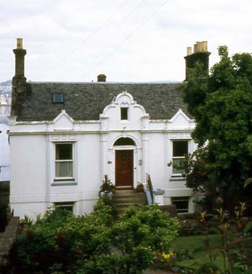
32-34 West Rd
Properties remaining on this plot outwith any sub-plots:
Sasine Abridgements (in reverse order):
| Ref | In Brief | Abridgement | Registered | Plot IDs | |
|---|---|---|---|---|---|
| 1880.05897 | Grant loan repaid | Disch by James David Grant disburd bond £500 (Mar 1878) by David Mackie Meldrum & Jacobina Ross of 54 pol 20.5 yd & dw ho t/on, : S by High Road to Woodhaven, : N by River Tay | 12 Jun 1880 | 227 | |
| 1878.02828 | loan by James David Grant | Bond £500 by David M Meldrum & disp by him & Jacobina Ross to James David Grant over 54 pol 20.5 yd & dw ho t/on, : S by High Road to Woodhaven, : N by River Tay | 21 Mar 1878 | 227 | |
| 1878.02822 | David James Grant to Jacobina Ross & David M Meldrum | Disp by David James Grant with consent to Jacobina Ross, liferent, & David M Meldrum, fee, of W-most half of 54 pol 20.5 yd & dw ho t/on, : S by High Road to Woodhaven, : N by River Tay | 20 Mar 1878 | 227 | |
| 1872.01496 | David Just to James David Grant | Disp by David Just to James David Grant of W-most half & ho t/on of 54 pol 20.5 yds grnd, bounded S by High Road, bounded N by River Tay | 24 Jul 1872 | 227, 216 |
Abbreviations in the notes
t/on - thereon; t/p - turnpike; dw - dwelling; ho - house; pt - part; pce - piece; grnd - ground; bldg - building; Tr/Trs - Trustee/Trustees; dec - deceased; ... - words omitted; pol - poles; yd - square yards; : - bounded; rd - road; ' - feet; " - inches;
Basic Types of Sasine Abridgements Worked example explaining the sasine transactions on the property pages Sasine entries - background information and explanation
Names in Sasines:
| 1880.05897 | Grant, James David |
| 1878.02828 | Grant, James David |
| 1878.02822 | Grant, James David |
| 1872.01496 | Grant, James David |
| 1872.01496 | Just, David |
| 1878.02828 | Meldrum, David M |
| 1878.02822 | Meldrum, David M |
| 1880.05897 | Meldrum, David Mackie |
| 1880.05897 | Ross, Jacobina |
| 1878.02828 | Ross, Jacobina |
| 1878.02822 | Ross, Jacobina |
Return to: Home Page Sasines 34 West Road 32 West Road